1: THE NAME AND THE LAND
CHAPTER 1
THE NAME AND THE LAND
The original native name of this particular area is MANIKA, and an abbreviation of IN-YA-KWA-NIKE meaning literally "The place of giving" or the old classic "Cornucopia", or horn of plenty. In the opinion of many, the description aptly describes the character of the region.
From the investigations of many writers, some ancient, (according to B.S. Trail Fairbridge), we now know that the Gold of Ophir meant the "Gold of Africa" and that of the many parts of Africa from which the gold was shipped, Sofala (near Beira) was one of the most important.
In fact the name "Ophir" naturally became "Sofala" by the usual evolvement of language, this "Ophir-Sophis-Sofira-Sofala", and as corroborative evidence we have the two rivers still producing gold on either side of Sofala, the Sabi and the Pungwe, both rising in the gold belt of Planika in the Umtali District. Sabi:- Saba-Sheba, and it was the Queen of Sheba (Sabi) who brought the gold to Solomon. Moreover, she brought it from the Land of Punt, which is the same as Puntwi" or "Pungwe". Further we have the direct internal evidence of our present name of Umtali, Umtali literally meaning "the river of gold , whilst the name of the old native Queen In-Ya-Kwa-Nike who lived on her conical hill at Penhalonga literally means "The place of giving".
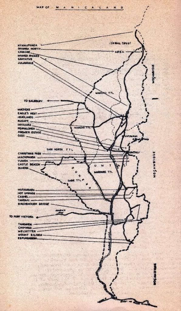
Before proceeding further take a bird's eye view of the terrain called Manicaland which we are about to cover, from North to South.
Migrating birds on reaching the borders of Rhodesia look down on a large channel of glittering mater making its way towards the Indian Ocean - the Zambezi, which has played a large part in the history of our Country. South of this is the northern area of Manicaland known as Inyanga North, the old' gold mining area. Here the Africans used to dive into deep rivers, bringing up the sand which they panned for gold. The grains of the precious metal, after being placed in quills, were carried in holes through the lobes' of their ears, and sold to the Portuguese. Birds, when passing over this lowveld area, where enormous baobab trees, kaffir oranges, monkey apples, and other tropical vegetation, must have seen elephants, buffaloes, kudus, zebra, lions, leopards and every other kind of game in large numbers.
From there they would pass over the Inyanga Mountains from the lowveld with an altitude of just over 1,000 feet rising to 3,000, 4,000, 6,000 and finally 7,000 feet up to Mount Inyangani,8,517 feet above sea level. Inyanga district is approximately 2,500 square miles in area. It is bounded on the east by Mozambique and north-west by the Makoni Tribal Trust Land. To the south of it is the Umtali district. As the central part is very mountainous, it contains the sources of many rivers flowing south-east and north, the most important being the Odzi, tributary of the Sabi.
End of Page 1
In the early days game was plentiful and the rivers flowing towards the Zambezi were full of fish. Here in the heights of Inyanga the spirits of the ancients have left their mark. When viewing the rivers, old forts and pits, one is conscious of an eerie atmosphere. If we follow the birds travelling south the altitude drops, and outcrops of granite hills appear here and there. There are plains and valleys with ample steams which account for the vegetation. Now and again mountain ranges appear, and below is seen the Umtali river cascading down the mountain side. Here is the village of Penhalonga and lower, Fort Hill, which the Pioneers occupied when they first entered Manicaland. North of this is the Divide where Cecil Rhodes, crossed the border and first entered the colony. A few miles to the south is -the renowned Christmas Pass which was an obstacle to be overcome by the old transport drivers.
Just over the pass, ringed by mountains, was once a large plain where one or two rough improvised farm dwelling houses dotted the veld. Muddy tracks or paths crossed the area. This is known as the Eastern Gateway to Rhodesia, where now the City of Umtali stands, almost on the borders of Mozambique. A short distance away is the scenic Vumba Mountain Range, originally known as Bvomba where chiefs were crowned and ancient rain forests, according to the local inhabitants, were inhabited by rain gods. Here elephants once made clearings through dense forests. Beyond the Vumba is another range known as the Rhodesian Himalayas, mountains which again fringe the Rhodesian Border, and actually are an extension of the Chimanimani mountains. From Umtali the birds we are following again fly over the lowveld from Umtali 3,552 feet down to approximately' 1,600 feet through baobab and mopani country until we come to the Melsetter district which is bounded on the east by Mozambique and to the north, west and south-west by the districts of Charter,. Bikita and Ndanga, from which it is divided by the Sabi River. The area is about 3,133 square miles. The district consists of a series of broken plateaux or altitudes. Not far from each other lie the villages of Melsetter and Chipinga. The land falls to the west and South, and the Chimanimani Mountains form part of the Mozambique boundary, and are known as the Manica Mountains, rising to 8,000 feet. Their stately heights are overwhelming, and the birds sing their praises to the
Creator.From here we speed on to an area of great granite hills. We pass Hot Springs and on to the Sabi where a bridge has been named after Sir Henry Birchenough - a silvery, arched structure which carries the road across the river and links up with the south. To the Africans the Sabi was known as the river that flowed both ways. The simple reason being that the sand-banks on each side were so steep, and the .country where it flows so level, that when in spate, owing to heavy rains, it often spilled over its banks and ran back as far as it could from whence it came. Further south is the Mukoriro range where the Moodie Pass is situated, and we will hear more about this in future. We pass the Mount Selinda where magnificent trees grow, some of them reaching a freight of 160 feet and 20 feet in circumference.
Continuing from here, still travelling south, we reach the' . last part of our journey down the Sabi on the boundary of Manicaland, where the Lundi River and the Sabi meet and leave us as they pass our borders into Mozambique. All that remains of Manicaland are vast areas of African Trust Lands known as Makoni, Maranki and Sabi.

End of Chapter
Click Here To Return to Index
Recompiled, by Eddy Norris, from a copy of the booklet made available by Neill Storey. Thanks Neill.
The recompilation was done for no or intended financial gain but rather to record the memories of Rhodesia.
The family of the author have given permission for ORAFs to load this booklet onto the Internet.
Thanks top the family and special thanks to Heather Curran.
Thanks to
Paul Norris for the ISP sponsorship.
Paul Mroz for the image hosting sponsorship.
Robb Ellis for his assistance.
Should you wish to contact Eddy Norris please mail him orafs11@gmail.com
posted by Rhodesia Remembered @ 15:32
0 Comments
![]()
![]()


0 Comments:
Post a Comment
Subscribe to Post Comments [Atom]
<< Home